
KMUTT Geospatial Engineering and Innovation Center
King Mongkut's University of Technology Thonburi
126 Pracha Uthit Road, 10140 Bangkok
Copyright (c) 2008 Sitename.com. All rights reserved.
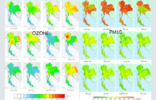
โครงการติดตามตรวจสอบและเฝ้าระวังคุณภาพอากาศ (การประเมินสถานการณ์คุณภาพอากาศของประเทศไทย)
Customer Pollution Control Department ในโครงการนี้ศูนย์ฯ ได้ดำเนินงานให้กับกรมควบคุมมลพิษ โดยศูนย์ฯ ได้ทำการศึกษาความเป็นไปได้ในการใช้ภาพถ่ายดาวเทียมในการตรวจจับและเฝ้าระวังคุณภาพอากาศในประเทศไทย ซึ่งในงานวิจัยนี้ทำการทดสอบการตรวจวัดข้อมูลคุณภาพโอโซนและ PM2/5 Other Projects
Read more.
โครงการระบบวิเคราะห์การสำรวจระยะไกลสำหรับประเมินและติดตามงานอ้อยของโรงงานน้ำตาลมิตรผล (ระยะที่ 1)
Customer Mitrphol Sugar ระยะที่ 1 ศูนย์ฯ ได้จัดอบรมการใช้งานซอฟท์แวร์ Dragon/ips เพื่อการวิเคราะห์ผลผลิตอ้อยรายปีของโรงงานน้ำตาลมิตรผลให้แก่เจ้าหน้าที่ของโรงงานน้ำตาลมิตรผล เพื่อพัฒนาความรู้ความสามารถให้แก่เจ้าหน้าที่ของโรงงานในการวิเคราะห์คุณภาพอ้อยและประมาณผลผลิตอ้อยรายปี โดยในการจัดอบรมจะมีในส่วนของการบรรยายและการฝึกปฏิบัติจริง Other Projects
Read more.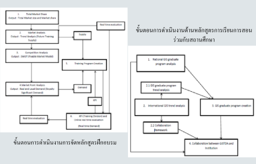
โครงการที่ปรึกษาศึกษาความเป็นไปได้ในการจัดหลักสูตรระดับปริญญาโท-เอก และหลักสูตรฝึกอบรมด้านภูมิสารสนเทศ
Customer Geo-Informatics and Space Technology Development Agency โครงการนี้ศูนย์ฯ ได้ดำเนินการให้กับสำนักงานพัฒนาเทคโนโลยีอวกาศและภูมิสารสนเทศ (องค์การมหาชน) หรือ สทอภ. โดยทางเราได้รวบรวมข้อมูลและทำการวิเคราะห์แนวทางการจัดหลักสูตรด้านเทคโนโลยีอวกาศและภูมิสารสนเทศระหว่าง สอทภ.
Read more.