
KMUTT Geospatial Engineering and Innovation Center
King Mongkut's University of Technology Thonburi
126 Pracha Uthit Road, 10140 Bangkok
Copyright (c) 2008 Sitename.com. All rights reserved.

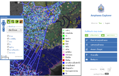
โครงการจัดทำแผนอนุรักษ์ฟื้นฟูแหล่งน้ำลำประโดงและวิถีชุมชน อำเภออัมพวา จังหวัดสมุทรสงคราม
Customer Department of water Resources ออกแบบและพัฒนาระบบภูมิศาสตร์สารสนเทศบนระบบเว็บแอพลิเคชั่น สำหรับเจ้าหน้าที่และผู้คนในท้องถิ่น โดยระบบที่จัดทำขึ้นนี้ประกอบได้ด้วย แผนที่แบบโต้ตอบอัตโนมัติซึ่งจะช่วยให้ผู้ใช้งานสามารถค้นหาลำคลองขนาดเล็ก หรือที่เรียกว่า “ลำประโดง” ได้ นอกจากนี้ผู้ใช้งานยังจะสามารถเข้าใจลักษณะ รวมไปถึงสถานะการใช้งานของลำประโดงต่างๆ
Read more.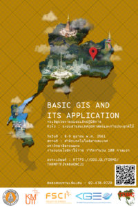
ขอเชิญร่วมงานอบรมเชิงปฏิบัติการ หัวข้อ ระบบสารสนเทศภูมิศาสตร์และการประยุกต์ใช้ (Basic GIS and its application)
เนื่องด้วย มหาวิทยาลัยขอนแก่น โดยศูนย์ความร่วมมือองค์การอนามัยโลกด้านการวิจัยและควบคุมโรคพยาธิใบไม้ตับ และบัณฑิตวิทยาลัย ได้เห็นความสำคัญของการนำความรู้ทางด้านเทคโนโลยีสารสนเทศภูมิศาสตร์มาประยุกต์ใช้ในงานทางการแพทย์และสาธารณสุข สัตวแพทย์และการผลิตสัตว์ ตลอดจนนักศึกษาในระดับบัณฑิตวิทยาลัยในสาขาที่เกี่ยวข้อง จึงได้ร่วมมือกับ ศูนย์วิศวกรรมสารสนเทศภูมิศาสตร์ มหาวิทยาลัยเทคโนโลยีพระจอมเกล้าธนบุรี จัดประชุมเชิงปฏิบัติการ ในหัวข้อ “Basic GIS
Read more.
GOFC-GOLD Materials
Materials on 5th March 2018 Download Here Materials on 6th March 2018 Download
Read more.