
KMUTT Geospatial Engineering and Innovation Center
King Mongkut's University of Technology Thonburi
126 Pracha Uthit Road, 10140 Bangkok
Copyright (c) 2008 Sitename.com. All rights reserved.

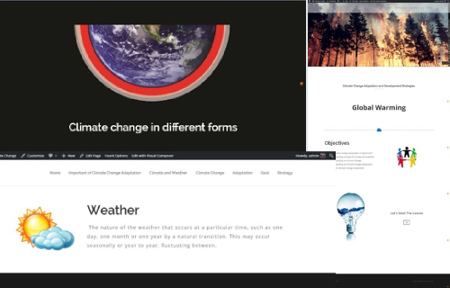
โครงการ Capacity Building Program on Community Vulnerability and Adaptation to Climate Change Assessment. (E-Learning Web)
Customer Southeast Asia START Regional Center ออกแบบและพัฒนาเว็บไซต์เพื่อเป็นสื่อการเรียนการสอนออนไลน์โดยเนื้อหาในการเรียนการสอนเกี่ยวกับการการเปลี่ยนแปลงของสภาพภูมิอากาศ ซึ่งโครงการนี้ศูนย์ฯ ได้จัดทำให้กับศูนย์ Southeast Asia START Regional จุฬาลงกรณ์มหาวิทยาลัย
Read more.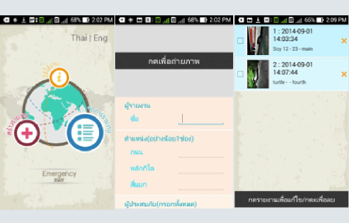
โครงการพัฒนาต้นแบบของแอพพลิเคชั่นบนโทรศัพท์มือถือเพื่อปรับปรุงการรายงานอุบัติเหตุบนท้องถนน
Customer The Thailand Research Fund ออกแบบและพัฒนาแอพพลิเคชั่นในระบบปฏิบัติการแอนดรอยด์เพื่อช่วยเหลือเจ้าหน้าที่จากหน่วยกู้ภัยในการรายงานอุบัติเหตุบนท้องถนนที่เกิดขึ้น และพัฒนาระบบฐานข้อมูลที่ใช้ในการจัดเก็บรายงานอย่างเป็นระบบเพื่อให้สามารถจัดการกับรายงานได้อย่างมีประสิทธิภาพมากยิ่งขึ้น Other Projects
Read more.
โครงการพัฒนาระบบควบคุมเรือสำรวจระยะไกลและระบบสร้างภาพสามมิติของสภาพแวดล้อม
Customer Hydro and Agro Informatics Institute ดำเนินการออกแบบและพัฒนาระบบจำลองโครงสร้างของคลองในรูปแบบสามมิติ โดยใช้ข้อมูลที่เก็บรวบรวมได้จากเรือหุ่นยนต์ โดยระบบจะนำข้อมูลทั้งหมดซึ่งประกอบไปด้วย ข้อมูลที่ได้จากการรังวัดด้วยเลเซอร์ (ความกว้างคลอง) เสียง (ความลึกคลอง )
Read more.