
KMUTT Geospatial Engineering and Innovation Center
King Mongkut's University of Technology Thonburi
126 Pracha Uthit Road, 10140 Bangkok
Copyright (c) 2008 Sitename.com. All rights reserved.

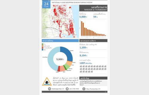
โครงการพัฒนาระบบประมวลผลและจัดทำแผนที่จากภัยน้ำท่วมแบบอัตโนมัติ (Flood monitoring)
Customer Geo-Informatics and Space Technology Development Agency การศึกษาและพัฒนากระบวนการประมวลผลข้อมูลดาวเทียมเพื่อจำแนกพื้นที่น้ำท่วมในโครงการนี้ ได้แบ่งการศึกษาออกเป็น 2 ส่วน ได้แก่ 1) การศึกษาและพัฒนากระบวนการจำแนกพื้นที่น้ำท่วมจากข้อมูลดาวเทียมในระบบ
Read more.
โครงการวิเคราะห์เวลาการเดินทางจำแนกตามความเชี่ยวชาญของโรงพยาบาลในกรุงเทพมหานคร
Customer ESRI (Thailand) Co., Ltd. โครงการวิเคราะห์และจัดทำแผนที่นำเสนอข้อมูลเวลาการเดินทางจากที่อยู่ผู้ป่วยถึงโรงพยาบาลในกรุงเทพมหานคร เพื่อให้ผู้ป่วยหรือผู้ใช้บริการสามารถวางแผนการเดินทางให้เหมาะสมตามแต่ละความเชี่ยวชาญของโรงพยาบาลได้ดียิ่งขึ้น ซึ่งการจัดทำโครงการนี้จะเป็นประโยชน์แก่หน่วยงานต่างๆ ไม่ว่าจะเป็นโรงพยาบาลในกรุงเทพมหานคร ประชาชนในกรุงเทพมหานคร หรือแม้แต่ในส่วนของภาครัฐบาล เช่น สำนักงานประกันสังคม สถาบันการแพทย์ฉุกเฉิน
Read more.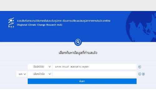
โครงการพัฒนาโปรแกรมประยุกต์ต้นแบบสำหรับการค้นหารายงานการวิจัยตามพื้นที่ในระดับภูมิภาค ในหัวข้อเรื่องการเปลี่ยนแปลงภูมิอากาศภายในประเทศไทย
Customer Thailand Research Fund ในโครงการนี้ เป็นโครงการพัฒนาต้นแบบโปรแกรมค้นหารายงานวิจัยที่แสดงผลเชิงพื้นที่ได้ในรูปแบบของเว็บแอพพลิเคชั่น ซึ่งส่งผลให้นักวิจัยที่มีความสนใจงานวิจัยทางด้านการเปลี่ยนแปลงสภาพภูมิอากาศเฉพาะพื้นที่ สามารถสืบค้นข้อมูลได้โดยง่าย และสามารถค้นหารายงานวิจัยที่ใกล้เคียงกันแต่พื้นที่การวิจัยแตกต่างกัน เพื่อนำมาเปรียบเทียบผลการวิจัยในแต่ละพื้นที่ได้ Other Projects
Read more.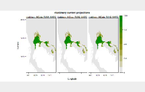
Mapping Regional Land Cover for Sustainable Rice Cultivation Using Geospatial Techniques and Satellite Data
Customer National Research Council of Thailand (NRCT) การศึกษาจะทำการรวบรวมข้อมูลที่เกี่ยวข้อง ทั้งข้อมูลเชิงพื้นที่ และข้อมูลเชิงบรรยาย ประกอบด้วย ข้อมูลปริมาณฝน อุณหภูมิ
Read more.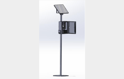
IoT: Sensor Web Enablement Air Quality Quantification System
Customer King Mongkut’s University of Technology Thonburi ศูนย์วิศวกรรมสารสนเทศภูมิศาสตร์และนวัตกรรม (KGEO) มีความสนใจสร้างระบบตรวจวัดคุณภาพอากาศ โดยใช้เทคโนโลยี Internet of Things
Read more.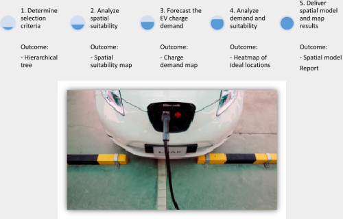
A spatial model for site selection analysis for electric vehicle DC fast charge infrastructure in Thailand.
Customer The Energy Policy and Planning Office (EPPO) การหาตำแหน่งที่ตั้งสถานีอัดประจุไฟฟ้าแบบเร็วที่เหมาะสม ด้วยการวิเคราะห์จากปัจจัยความต้องการของสถานีอัดประจุไฟฟ้ากระแสตรงแบบเร่งด่วน (DC Fast Charging
Read more.